Please select an article from the left menu to display its content.
The Zone module lets you define geographic delivery/pickup zones by drawing a boundary on a map and mapping postal codes to it. Zones are used to auto-assign shipments and deliveries to the right couriers and operating units based on where an address falls.
Overview
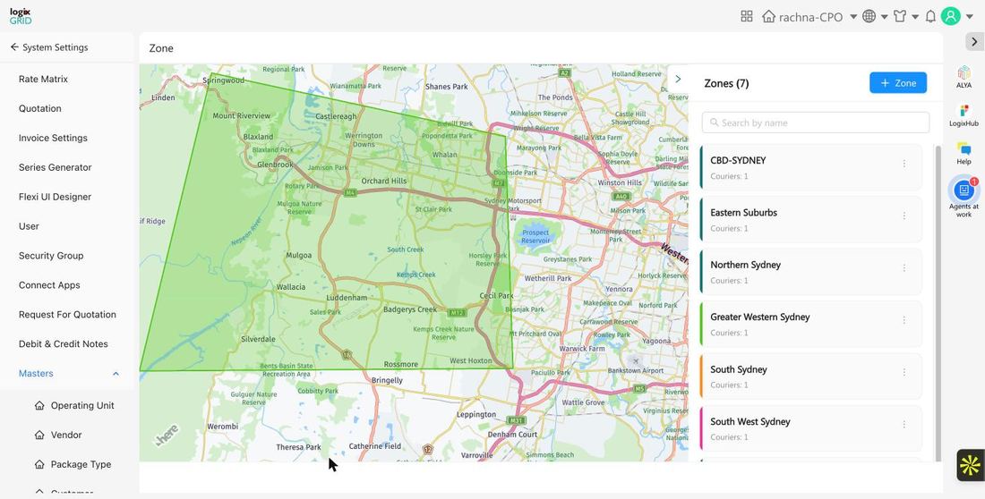
A Zone represents a defined coverage area — such as a suburb, district, or delivery region — drawn directly on a map and linked to one or more postal codes. Each zone belongs to an Operating Unit and can have drivers assigned to it. Zones appear as colored polygons on the Zone map view, alongside a list of existing zones and how many couriers are currently linked to each.
Prerequisites
- Admin or System Settings access to configure Masters.
- At least one Operating Unit already created, since every zone must be linked to one.
- Drivers should already exist in the system if you plan to assign them directly to the zone.
Create a New Zone
- Go to System Settings → Masters → Zone.
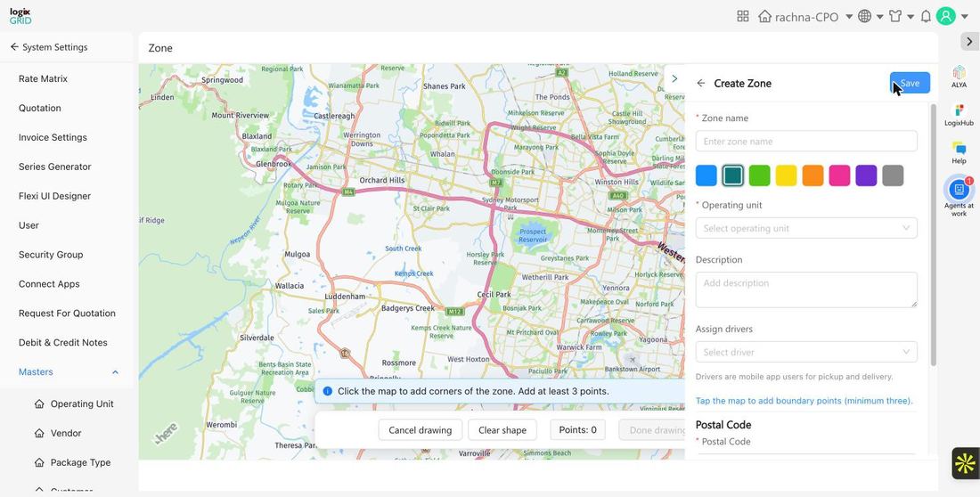
- Click + Zone to open the zone creation form.
- Enter a Zone Name and pick a Zone Color from the preset swatches so the zone is easy to distinguish on the map.
- Select the Operating Unit the zone belongs to, and optionally add a Description.
- Optionally choose one or more Assign Drivers — these are mobile app users who handle pickup and delivery within the zone.
- On the map, tap to add boundary points and draw the zone's polygon. A minimum of three points is required to form a valid boundary.
- In the Postal Code section below the map, add the postal codes that fall within this zone.
- Click Save to create the zone.
Field Reference
| Field | Required | Description | Examples / Notes |
|---|---|---|---|
| Zone Name | Yes | Descriptive name for the zone. | CBD-Sydney, Eastern Suburbs, Northern Sydney |
| Zone Color | No | Color used to visually distinguish the zone's polygon on the map. | 8 preset color swatches |
| Operating Unit | Yes | The operating unit (branch/office) this zone is associated with. | rachna-CPO, Vancouver |
| Description | No | Free-text notes about the zone's coverage or service level. | e.g. "Same-day delivery zone" |
| Assign Drivers | No | Mobile app users (drivers) responsible for pickup and delivery within this zone. | Multi-select from existing Driver records |
| Boundary Points | Yes | Points tapped on the map to draw the zone's polygon boundary. | Minimum of 3 points required |
| Postal Code | Yes | One or more postal/ZIP codes that fall within this zone. | e.g. 2000, 2010 |
Usage Across Modules
- DMS / FreightNX: Zones are used to auto-match a shipment's pickup or delivery address (via postal code) to the correct coverage area, which drives courier and operating-unit assignment.
- Driver Assignment: Drivers linked to a zone are prioritized when tasks fall within that zone's boundary.
- The number of couriers linked to each zone is shown directly on the zone list view.
Notes / Best Practices
- Keep zone boundaries non-overlapping where possible to avoid ambiguous courier assignment.
- Use distinct zone colors for adjacent zones so they're easy to tell apart on the map.
- Review and update postal code lists whenever service areas change.
- Draw boundaries with enough points to reasonably match the real coverage area — a minimum of three points is required, but more points give a more accurate shape.
FAQs
- Can a postal code belong to more than one zone?
- Postal codes should generally be assigned to a single zone to avoid conflicting courier or operating-unit assignment.
- What happens if a delivery address doesn't match any zone?
- Shipments with an address outside all configured zone boundaries will not be auto-assigned via zone matching and may need manual assignment.
- Can I edit a zone's boundary after it's created?
- Yes. Open the zone from the list and adjust the map boundary points, then save your changes.